Understanding the Official Plan
The Official Plan is the blueprint for the City of Toronto. It outlines land use policies and ensures that growth is coordinated. It directs the use of all land, now and in the future, as well as where our infrastructure and community services will be built. It provides a framework for creating and updating Zoning By-laws, which set regulations and standards, and establishes a method for evaluating land use conflicts while meeting government interests.
The Official Plan incorporates a set of urban structure policies, which direct growth to areas of the City which are best served by existing infrastructure. This includes properties with access to rapid transit as well as frequent and reliable surface transit. It also includes properties which possess significant development potential, with access to major street networks. The Plan establishes a classification system and specific boundaries for these areas. The Downtown, along with the City’s other four major centres (Yonge and Eglinton, North York Centre, Etobicoke Centre and Scarborough Centre), are planned to accommodate the most significant portion of future growth through some combination of mid- to high-rise development. The Avenues, which comprise the City’s major corridors, are anticipated to accommodate low- to mid-rise development, while establishing appropriate transitions in building height, building mass, and use between these corridors and adjacent established neighbourhoods. Among others, these Avenues include segments of King Street, Queen Street, Dundas Street, College Street, Bloor Street / Danforth Avenue, Bathurst Street, Avenue Road, Yonge Street and Kingston Road.
In addition to the Urban Structure, the Official Plan incorporates a set of land use designations and supporting policies, which regulate the use of land throughout the City. One such designation is “Neighbourhood” (denoted with a capital "N"). The Official Plan broadly identifies a range of potential building types, which may be appropriate throughout the City’s Neighbourhoods. These include detached houses, semi-detached houses, duplexes, triplexes, townhouses, and walk-up apartment buildings. The Plan envisions that all Neighbourhoods will remain 4 storeys or less in height, with relatively low densities. While some degree of change is anticipated to occur through renovations, additions and infill development, Neighbourhoods are to remain physically stable, and are not targeted for intensification. The Plan sets out policies and evaluation criteria to assist with the review of development proposals, in order to ensure that they are consistent with the physical character of the Neighbourhood. In doing so, the Plan makes several references to existing Zoning regulations.
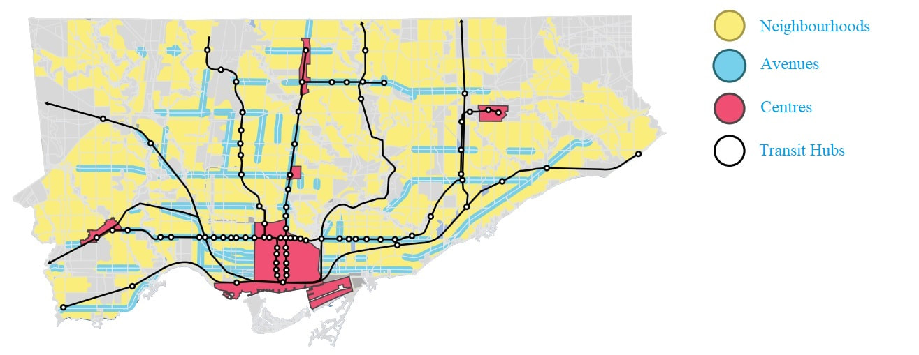
(Above) Map illustrating the location of Centres, Avenues, Neighbourhoods and Transit Hubs throughout the City of Toronto, prepared by SvN Architects + Planners Inc. on behalf of the Ontario Association of Architects Housing Affordability Task Group.
Understanding the Zoning By-law
The Zoning By-law implements the policies of the Official Plan. It regulates the use of land by establishing a classification system of Zones, each with a unique set of performance standards, and then assigning a Zone to each property throughout the City. It's performance standards address everything from the range of permitted uses to appropriate lot sizes, setbacks, building heights, massing, densities, and parking requirements. Collectively, these performance standards establish an envelope for development.
Prescription and Ambiguity
The Neighbourhood land use designation occupies over half of the City’s physical land mass, and over 70 percent of its developable land area. The policies associated with this designation are overly prescriptive in nature. However, aspects of these policies are also written with a degree of ambiguity, which leaves them open to interpretation and debate – the subject of countless Ontario Municipal Board (OMB) and now Local Planning Appeal Tribunal (LPAT) hearings. Beyond this ambiguity, the general direction of the Neighbourhood land use policies is counter-productive, contributing towards the creation of Neighbourhoods which are static and inflexible.
Within the Neighbourhoods land use designation, about one third of the City’s physical land mass, roughly 20,000 hectares of land, is Zoned exclusively for detached single-family dwellings. While the remainder of Neighbourhoods permit this in combination with other building types, the majority are reserved solely for the combined development of detached and semi-detached single-family dwellings. This begs the question – how many housing units are there, and what level of diversity exists?
Within the Neighbourhoods land use designation, about one third of the City’s physical land mass, roughly 20,000 hectares of land, is Zoned exclusively for detached single-family dwellings. While the remainder of Neighbourhoods permit this in combination with other building types, the majority are reserved solely for the combined development of detached and semi-detached single-family dwellings. This begs the question – how many housing units are there, and what level of diversity exists?
Toronto contains approximately 850,000 detached single-family dwellings. This is roughly 40 per cent of the it's total housing inventory. In contrast, the City contains approximately 320,000 semi-detached and row-house dwellings and approximately 308,000 townhouse, multi-plex and low-rise apartment units. This totals roughly 14 and 15 per cent of its total housing inventory, respectfully. This means that there are 11 per cent more detached single-family dwellings in Toronto than all other forms of low-rise residential housing, combined. The majority of the City’s semi-detached, duplex, triplex, fourplex and walk-up apartment buildings pre-date modern Zoning regulations. While they are permitted in older areas of the City, where they were originally constructed, they are generally not supported by Zoning regulations in areas outside of the Former City of Toronto and East York (i.e. North York, Scarborough and Etobicoke). Given this, they do not represent common forms of ground-related housing within newer communities and are effectively missing from the housing equation.
Based on this analysis, we can see that our City’s overly prescriptive yet ambiguous policies prevent the diversification of the low-rise housing stock, while constraining its supply. It is also important to note that the City of Toronto has developed to its geographic extents. In the absence of more flexible policies and regulations, which encourage some degree of neighbourhood growth and reinvestment through conversions, additions, infill and intensification, the City’s Neighbourhoods are treated, through a policy lens, as being physically built-out at their desired and intended density.
So, we understand that there is a mismatch between the types of housing which are being supplied, and those which are demanded. We also understand that this is largely driven by the City's municipal land use policy framework. Are these issues being compounded by changing demographic patterns? Please click Demographics to learn more.