Transition Zones

Policy history

Toronto’s changing housing framework.

Several Toronto initiatives now address the relationship between growth areas and nearby neighbourhoods. This history sets out where the logic appears, what each instrument does and what remains to be implemented.

The examples below are related in different ways. Some establish mapped permissions beyond a main street, while others change a corridor building’s relationship to its immediate neighbours. Each entry links to its source and identifies its status.

Sources reviewed 10 November 2026

2019

Provincially modified Official Plan

Yonge–Eglinton: targeted neighbourhood intensification

The Province approved OPA 405 with substantial modifications to the City’s Yonge–Eglinton Secondary Plan. Modified policy 2.1.3 identifies Neighbourhoods A and B as suitable locations for more intensive low-rise forms, including townhouses, stacked townhouses and low-rise apartments. Modified policy 2.5.12 supports incremental intensification and a wider range of residential uses in Neighbourhoods A.

The changes apply to defined areas within Midtown. They provide an early example in this history of neighbourhood intensification being addressed through mapped policy distinctions.
2022

Council-adopted area policy and urban design guidance

Danforth: opportunities on selected blocks behind the avenue

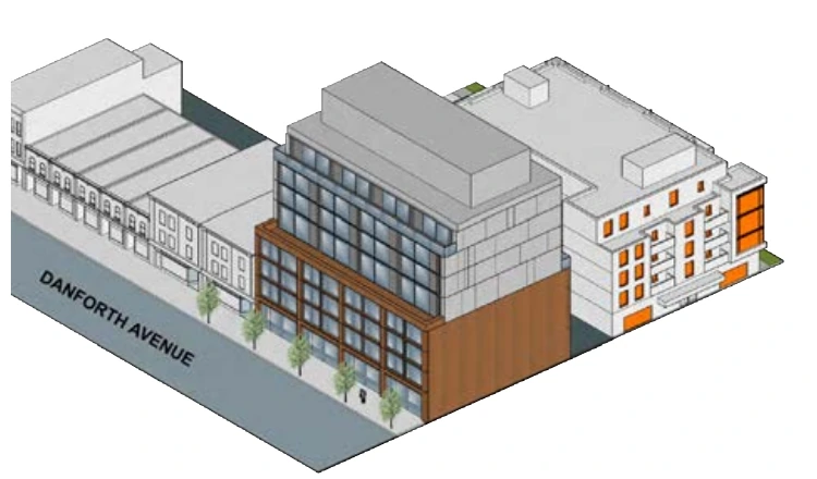
The Danforth Segment 2 framework, from the Don Valley to Coxwell Avenue, includes selected Neighbourhood lands behind the main street: lots immediately north and south of parking facilities or parks between Chester and Langford, plus collections of two or three lots on certain side streets. Policy Areas B–E and their mapped boundaries distinguish the different conditions.

The resulting SASP 772 and guidelines were adopted in April 2022. They provide an area-specific example of planning beyond Danforth’s fronting lots. SASP 772, sections 6.2–6.7 and Maps 3A–3B, should be read with the guidelines. Adoption of an area policy or guideline should not be read as a blanket zoning permission for every property behind the avenue; applicable appeals, later decisions and site requirements need to be checked.

City of Toronto conceptual massing showing a mid-rise Danforth building and additional lower-scale housing on selected parcels behind it
City illustration / 2022

The City’s illustration shows how additional housing can extend behind Danforth-fronting buildings. It depicts intended massing, not a specific approved development.

Source: City of Toronto. Danforth Urban Design Guidelines · Diagram 1, page 36.
2022

December Council direction / Housing Action Plan

Tory and Bradford bring Transition Zones into Council’s housing direction

On 14 December 2022, Council approved the Housing Action Plan brought forward by Mayor John Tory and seconded by Councillor Brad Bradford, then Chair of the Planning and Housing Committee. The direction expressly included amending the Zoning By-law to create transition zones between commercial and residential areas.

Council directed the City Manager to report back by March 2023 with implementation details, timelines and targets. This was the political direction that preceded the more detailed Housing Action Plan work program and its standalone Transition Zones tasks.

2023

Housing Action Plan / standalone review identified

Transition Zones becomes a distinct City work item

The Housing Action Plan identifies a Transition Zones zoning review and updates to the Townhouse and Low-Rise Apartment Guidelines. It connects the guideline work to the emerging mid-rise standards, establishing a place for this work within the City’s wider housing program.

The Q3 2025 tracker scheduled Transition Zones proposals and final reports for Q2 2026. It separately listed the guideline update for Q4 2026. The Q2 reporting targets have passed; the Q4 guideline target had not yet passed at the November 10, 2026 review date. A completed standalone citywide framework was not identified in the public material reviewed for this site. An updated delivery program is needed.

2024–26

Updated guidance / continuing implementation work

Mid-rise reform changes how corridor edges are designed

The City updated rear-transition standards and, in December 2024, directed use of draft Mid-Rise Building Design Guidelines in evaluating proposals. The guidelines remove angular-plane requirements and change the design approach to mid-rise buildings.

The City’s current implementation page anticipates further guideline consideration in Q1 2027. This work is related to Transition Zones, while often operating at the scale of the corridor building and its immediate edge. Changes to the corridor envelope do not, on their own, establish new permissions for the separate neighbourhood properties behind it.

2024

Council-adopted secondary plan / appeals require attention

Renew Sheppard East explicitly names Transition Zones

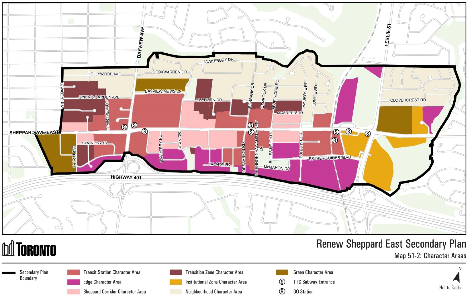
OPA 777 identifies a Transition Zone Character Area on selected blocks north and south of Sheppard Avenue East. Policies 3.5.1–3.5.3 call for intermediate low-rise and mid-rise forms, housing variety, landscaped settings, connections and local-serving uses. Policy 7.7.1 expressly addresses buildings fronting local streets.

The express reference to local streets makes this a useful example of transition being planned beyond the corridor frontage. Map 51-2 identifies the affected areas, including portions of blocks around Spring Garden, Clairtrell, Elkhorn, Granlea and Talara. Council adopted the plan in December 2024; subsequent appeal-related directions mean its status must be checked before treating any site as having implemented permissions.

Renew Sheppard East Map 51-2 with complete legend, showing dark-brown Transition Zone Character Areas behind parts of the Sheppard corridor
Council-adopted December 2024 / subject to appeals

The dark-brown areas identify the plan’s Transition Zone Character Area. The map locates these areas beyond the main corridor and distinguishes them from other character areas.

Source: City of Toronto. Renew Sheppard East · Map 51-2, PDF page 36.
2025–26

Minister-approved Official Plan / zoning implementation underway

Station-area policies reach into neighbourhood interiors

On 15 August 2025, the Province approved modified Official Plan policies for 120 Toronto MTSAs and PMTSAs. On Neighbourhood-designated lands within these approved areas, multiplexes and apartment buildings are permitted up to four storeys; up to six storeys are permitted within 200 metres of an existing or planned station, or with frontage on a Map 3 major street.

The permissions can apply on local streets within neighbourhood interiors. They apply within approved, delineated station areas, not around every station automatically. Other policies and any greater applicable density permissions still matter. The City’s current implementation page distinguishes the in-effect Official Plan policies from the ongoing zoning exercise.

2026

Council-endorsed directions / Secondary Plan update in progress

North York Centre: transition beyond Beecroft and Doris

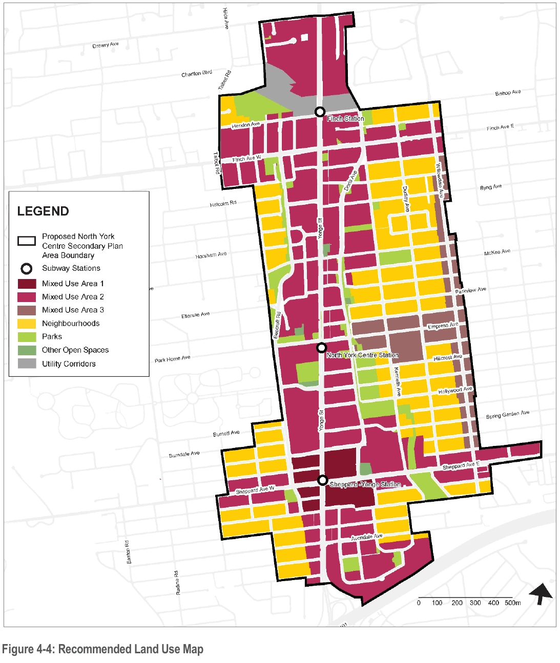
Council endorsed the November 2025 Final Options and Directions Report in March 2026 as the basis for the next phase of the review. The directions identify a transitional district between Beecroft Road and Basswood Avenue, and between Doris Avenue and Kenneth Avenue, with new mid-rise opportunities beyond the existing tower corridor.

The land use approach is selective. Some Neighbourhood lands would become Mixed Use, while substantial areas would retain their designation. The six-storey condition applies to Neighbourhood lands along proposed Major Streets within PMTSAs, including portions of Doris and Beecroft. Other proposed mid-rise areas have different heights.

The updated Secondary Plan has not yet been adopted. An April 2026 supplementary option evaluates retaining more Neighbourhood-designated lands along Empress and northern Willowdale. Boundaries and designations remain under refinement; the City schedules draft-plan engagement for early 2027.

November 2025 recommended North York Centre land-use map with complete legend, proposed boundary, yellow Neighbourhood areas and selected Mixed Use Areas
November 2025 study recommendation / plan update in progress

The recommended map retains substantial Neighbourhood areas in yellow and identifies selected Mixed Use Areas. Council endorsed directions for further work in March 2026; this is not an adopted replacement Secondary Plan. The April 2026 supplementary work considers further alternatives.

Source: City of Toronto. Options and Directions · Figure 4-4, PDF page 112.

Related approaches

Related approaches
and the tools they use.

These examples use related approaches at different scales. The comparison concerns their planning effect; it does not establish that they adopted the original proposal in full.

AreaHow transition is handledExtent and status
Mount DennisThe approved plan identifies a transition area generally 60 metres from the Weston Road centreline. Policy 8.41.2 limits the band generally 50–60 metres from the centreline to four storeys, about 12 metres.A narrower corridor-edge mechanism. OPA 571 was approved, as modified, by the OLT in October 2024, except site-specific appeals. Approved order · policy 8.41
Jane FinchSelected Neighbourhood lands around Elana, Driftwood/Potsdam, Finch/Yellowstone and Topcliff are redesignated. The plan also maps heights and transition directions across blocks toward lower-scale areas: see Map 50-6 and policy 8.4.3(d).A broader district framework, rather than a uniform missing-middle band. In effect from February 2025 with exceptions, including remaining Norfinch appeals. Current study status OPA 633
Lake Shore Boulevard West (draft)The June 2026 draft guidelines identify Transition Zones behind selected frontage blocks near Long Branch GO. They combine rear-lot consolidation with space for low-rise housing, access, servicing and open space.Draft framework. Council referred the item back in July 2026 for further work in Q1 2027. This approach is tied to consolidated corridor-development sites. June 2026 draft · section 3.1.4 and Figure 13 July 2026 Council referral
Major Streets & AvenuesBroader corridor permissions and Avenues policy changes create opportunities for more housing near existing neighbourhoods. They alter the context within which transition is assessed.Related reforms with their own mapped applicability. Corridor frontage alone does not establish a neighbourhood-wide Transition Zone. Major Streets Avenues review
Implementation / The outstanding workRead the policy options and the action being sought